Hail in Wadmalaw Island, SC
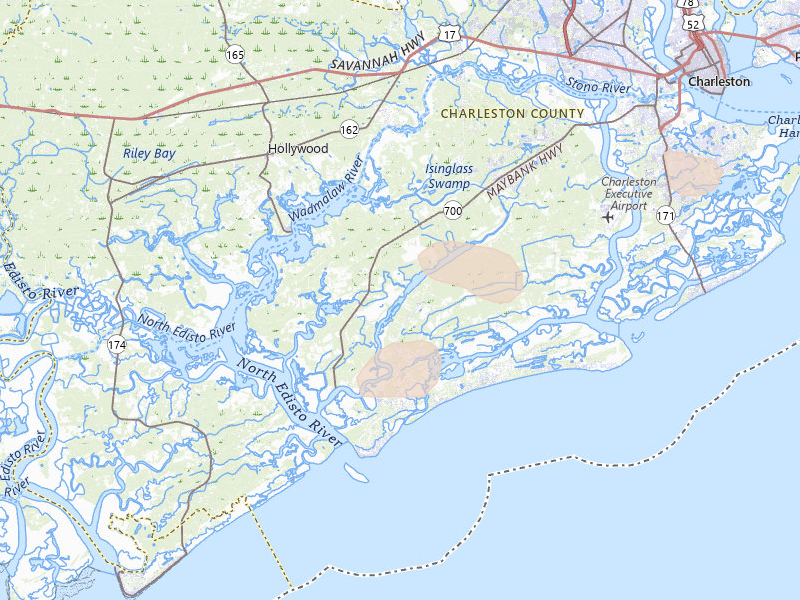
1 storm day since Jul 12, 2026. Biggest: 1.25" (half-dollar) on Jul 12, 2026, NEXRAD radar signature. About 660 homes sit inside the mapped footprints. Open the Jul 12, 2026 storm on the live map, or pick a date below.

7-day free trial in the iPhone app. No card required to start.
For iPhone. Android coming soon.

Web trial: 7 days free. Card required. $150/month after the trial unless cancelled.
Record window · Jul 12, 2026
Activity record / trailing 12 months
Every Wadmalaw Island storm day, month by month.
The chart shows every recorded storm day in the current 12-month window. The archive below keeps the full history.
Hail storm days in Wadmalaw Island over the last 12 months, by month: 1 total across 1 month — July 2026 (1 day, up to 1.25").
Ranked by total hail severity — the sum of every storm's largest hailstone over the last 12 months.
Storm archive / map evidence
Every recorded storm day.
Newest first. Each date opens a full report with both radar surfaces when available, severity context, and filed ground observations.
No surprises
From the App Store to your next area
- 01Get the iPhone app
Download Overview from the App Store and create your account.
- 02Start your free trial
Try the app for 7 days with no card required to start. Choose whether to subscribe when the trial ends.
- 03Set your territory
See the hail context, review recommended work areas, and choose your next place to prospect.
- Then you’re in Start free trial
Web trial: 7 days free. Card required. $150/month after the trial unless cancelled.
FAQ
Hail in Wadmalaw Island: quick answers
When did it last hail in Wadmalaw Island?
The most recent recorded hail in Wadmalaw Island fell on Jul 12, 2026. It is the only hail day on record since Jul 12, 2026.
What's the largest hail signal recorded in Wadmalaw Island?
The highest radar-indicated hail size recorded in Wadmalaw Island was 1.25" — about the size of a half-dollar — on Jul 12, 2026. That figure is a NEXRAD radar signature, not a ground measurement.
How often does Wadmalaw Island get hail?
Overview recorded 1 hail day in Wadmalaw Island over the last 12 months. Across all records, 1 hail day has been logged since Jul 12, 2026.
Can I still file an insurance claim for hail damage in Wadmalaw Island?
Wadmalaw Island has had 1 recorded hail storm in the last 24 months. Homeowner insurance policies commonly allow one to two years to file a hail-damage claim, but deadlines vary by policy and state — check your policy or ask a roofer for an inspection. This is general information, not legal or insurance advice.
How many homes are inside Wadmalaw Island's mapped hail areas?
Roughly 660 homes sit inside Wadmalaw Island's recorded hail footprints, based on building-footprint data intersected with the recorded hail.
How do I get a list of homeowners inside a mapped hail area in Wadmalaw Island?
Use Overview on iPhone to explore Wadmalaw Island hail, choose a recommended area or draw your own, and work the addresses inside it. The iPhone onboarding trial lasts 7 days, includes 200 addresses, and requires no card to start. Optional homeowner contacts cost $0.21 each where available. Web checkout has separate trial terms; see the pricing page.
How accurate is the Wadmalaw Island hail map?
Each Wadmalaw Island storm date is drawn from two radar surfaces — NEXRAD hail signatures and a radar-estimated hail size — with the NWS ground reports filed that day shown beside them. Radar is not ground truth: it can run larger or smaller than what fell, and it cannot see a single roof. Use the map to rank where to inspect first, then let the inspection decide.
NOAA's storm reports are free — what does Overview add?
We use them: every NWS report filed over Wadmalaw Island is pinned to the map. What Overview adds is every storm date rendered as a swath over the streets, the estimated hail size in inches, a replay of any past day, the count of homes under the footprint, and the homeowner list for whatever shape you draw.
Nearby
Hail near Wadmalaw Island
Johns Island, SC
1,428 homes in mapped areas · 3 storm days in 12 months
Latest signal Aug 22, 2026Hollywood, SC
40 homes in mapped areas · 2 storm days in 12 months
Latest signal Aug 22, 2026Ravenel, SC
7 homes in mapped areas · 4 storm days in 12 months
Latest signal Aug 13, 2026Edisto Island, SC
0 homes in mapped areas · 1 storm day in 12 months
Adams Run, SC
5 homes in mapped areas · 3 storm days in 12 months
Latest signal Aug 22, 2026Folly Beach, SC
0 homes in mapped areas · 2 storm days in 12 months
Latest signal Jul 26, 2026Overview Pro · iPhone + web
Take Wadmalaw Island into the field.
The hail map, your next recommended area, and the tools to work it. Start on your own; the same subscription also includes access for up to 4 team members.
Overview Pro
One plan · iPhone + webMonthly · US App Store
$149.99 / month
5,000 new addresses per user each month on Pro. Try the app with 200 addresses during your free trial.
Optional outreach
- + $0.21 per contact returned
- Available homeowner names and phone numbers, with freshness and DNC flags.
- + $0.75 per postcard mailed
- Print, postage, and delivery tracking included.
What's included
Get recommended places to prospect, or draw your own. The same plan gives you the tools to work either one.
- Hail maps, storm history, and live radar
- Curated prospecting recommendations and Quests
- Canvassing sessions and navigation
- Door outcomes, notes, and photos
- Visit history and follow-up Quests
- Alerts for your saved territories
- Polygon and hexagon draw tools
- Saved work areas and address lists
- CSV exports for your dialer or CRM
- XP, levels, and the leaderboard
- Access on iPhone and the web
- Up to 4 team members
7-day free trial in the iPhone app. No card required to start.
Choose whether to subscribe when your trial ends. Paid subscriptions renew monthly. Manage or cancel in your Apple Account settings.
See all pricing and billing details →Web trial: 7 days free. Card required. $150/month after the trial unless cancelled.
Take your next area into the field.
See the hail, review your recommendations, and canvass with Overview on iPhone.
7-day free trial in the iPhone app. No card required to start.
For iPhone. Android coming soon.
Web trial: 7 days free. Card required. $150/month after the trial unless cancelled.